hedayatgeo.info • Hedayat Explorer —

Software Features

Every module and capability, extracted directly from the product.

◳Real screenshot pending
Available
System & Platform

Main Console & 14-Step Engine

کنسول اصلی و موتور ۱۴ مرحله‌ای

The central workspace of Hedayat Explorer: loads the data file, configures all processing parameters, and runs the proprietary 14-step Hedayat pipeline to produce the final anomaly map and extract targets. Includes a results gallery of every processing stage.
Use case: Primary processing of magnetic / geophysical survey data into interpretable target maps.
Related: Matrix Generator Device / Telemetry Reader Professional Map & Spectral Filters
◳Real screenshot pending
Available
Data Acquisition & Scanning

Device / Telemetry Reader

خوانندهٔ دستگاه / تله‌متری

Reads raw telemetry files from magnetometers and UAV survey systems and converts them into the standard Hedayat data file for processing.

Use case: Ingesting field-acquired sensor data.
Related: Main Console & 14-Step Engine UAV Magnetometer Processing
◳Real screenshot pending
Available
Processing & Filtering Engine

Matrix Generator

تولید ماتریکس

Builds the regular grid matrix from raw scattered data points, the foundation for all gridding and filtering operations.

Use case: Preparing data for 2D/3D processing.
Related: Main Console & 14-Step Engine
◳Real screenshot pending
Available
Data Acquisition & Scanning

Smart Auto-Scan

اسکن هوشمند

Automated block-by-block scanning of large survey areas using the Hedayat engine, with block computation, resume, pause/stop, and per-date scan galleries.

Use case: Large-area automated prospecting surveys.
Related: Main Console & 14-Step Engine Satellite Map Panel
◳Real screenshot pending
Available
Data Acquisition & Scanning

Live Scanner

اسکن زنده

Real-time acquisition panel that streams and visualizes scanner data live during field operation.

Use case: On-site live monitoring of scans.
Related: Device / Telemetry Reader Smart Auto-Scan
◳Real screenshot pending
Available
Data Acquisition & Scanning

TeroVido / Scanner Import

وارداتِ TeroVido و اسکنر

Imports TeroVido and compatible 3D scanner formats (X Y Z Value), mirroring, line correction and export to the Hedayat engine.

Use case: Interoperability with third-party ground scanners.
Related: Smart Analyzer (t3d / VTK) Virtual Voxler — Internal 3D Engine
◳Real screenshot pending
Available
Processing & Filtering Engine

Hedayat Proprietary Filters (14-Step)

فیلترهای اختصاصی هدایت (۱۴ مرحله)

The signature multi-stage filter chain: search-angle gridding, slope/derivative filters, resolution separation, dual edge filters, background removal, smoothing, soil calibration, and hotspot target extraction — all parameterized and repeatable.

Use case: Enhancing and isolating sub-surface anomalies.
Related: Main Console & 14-Step Engine Professional Map & Spectral Filters Independent 14-Step Module
◳Real screenshot pending
Available
Processing & Filtering Engine

Smart Filters

فیلترهای هوشمند

An adaptive filter set that selects and tunes enhancement parameters automatically for cleaner anomaly separation.

Use case: One-click enhancement for non-expert users.
Related: Hedayat Proprietary Filters (14-Step)
◳Real screenshot pending
Available
Processing & Filtering Engine

Independent 14-Step Module

ماژول مستقل ۱۴ مرحله‌ای

A standalone implementation of the 14-step engine, isolated from the main pipeline and from Surfer/Voxler paths, for reproducible batch processing.

Use case: Scripted / reproducible reprocessing.
Related: Hedayat Proprietary Filters (14-Step)
◳Real screenshot pending
Available
Geophysics & Inversion

Professional Map & Spectral Filters

نقشهٔ حرفه‌ای و فیلترهای طیفی

Industry-standard potential-field processing: Reduction to Pole (RTP), vertical/horizontal derivatives and gradients, Total Horizontal Derivative (THD), Tilt angle, Analytic Signal, upward/downward continuation and Euler deconvolution, with final anomaly mapping and target separation.

Use case: Quantitative magnetic/gravity interpretation.
Related: UAV Magnetometer Processing Advanced Geophysics — 3D Inversion
◳Real screenshot pending
Available
Geophysics & Inversion

UAV Magnetometer Processing

پردازش مغناطیس‌سنج پهپاد

Dedicated processing of drone-borne magnetic surveys: feeding the Hedayat engine and producing 2D/3D anomaly maps.

Use case: Airborne magnetic prospecting.
Related: Professional Map & Spectral Filters Advanced Geophysics — 3D Inversion
Advanced Geophysics — 3D Inversion ⤢ Available
Geophysics & Inversion

Advanced Geophysics — 3D Inversion

ژئوفیزیک پیشرفته — وارون‌سازی سه‌بعدی

Full 3D susceptibility inversion from magnetic data, producing a voxel model with isosurfaces, body volume computation, shell transparency, dense-core highlighting, center-of-mass points, and regional/residual separation. Exports directly to the internal 3D view and to Voxler.

Use case: Depth/geometry modeling of buried sources.
Related: Virtual Voxler — Internal 3D Engine Voxler 4 Automation UAV Magnetometer Processing
◳Real screenshot pending
Available
Geophysics & Inversion

GPR Processing

پردازش رادار نفوذی (GPR)

Ground Penetrating Radar processing: radargram handling, anomaly extraction, 2D grid export for Surfer and voxel/CSV export for 3D interpretation.

Use case: Shallow sub-surface and utility/void detection.
Related: Export Formats & Reporting Web 3D View & Voxler Simulator
◳Real screenshot pending
Available
Geophysics & Inversion

Virtual Excavation Simulator

شبیه‌ساز حفاری مجازی

Removes surface layers down to a chosen depth from the 3D view to reveal the body beneath, aiding dig planning.

Use case: Planning and previewing excavation.
Related: Advanced Geophysics — 3D Inversion Virtual Voxler — Internal 3D Engine
◳Real screenshot pending
Available
Satellite & Remote Sensing

Satellite Intelligence Engine

موتور هوش ماهواره‌ای

Satellite analysis engine with rigorous CRS/geodetic control (coordinate reference validation, axis order, units, tiepoint consistency — fail-closed) and multi-scale analysis. 106 automated unit tests.

Use case: Geo-referenced satellite data analysis.
Related: Remote Sensing Satellite Map Panel
◳Real screenshot pending
Available
Satellite & Remote Sensing

Remote Sensing

سنجش از دور

Remote-sensing workspace for multi-scale analysis of imagery, anomaly and feature detection over survey areas.

Use case: Image-based surface reconnaissance.
Related: Satellite Intelligence Engine DEM Intelligence
◳Real screenshot pending
Available
Satellite & Remote Sensing

DEM Intelligence

هوش DEM

Digital Elevation Model intelligence: UAV micro-topography, hillshade/relief rendering, local-relief enhancement and raster handling.

Use case: Terrain and micro-relief analysis.
Related: Remote Sensing Hedayat Converter
◳Real screenshot pending
Available
Mapping & Geospatial

Satellite Map Panel

پنل نقشهٔ ماهواره

In-app satellite basemap with coordinate read-out, point saving, block grids and target marking; supports offline tile download for internet-free operation.

Use case: Field navigation and target geolocation.
Related: Google Earth Integration Offline Map Download
◳Real screenshot pending
Available
Mapping & Geospatial

Google Earth Integration

یکپارچگی گوگل‌ارث

Point-grid generation with online SRTM elevation, KML/KMZ import/export, multi-layer KMZ packaging, raster coloring presets, dual-scan comparison, and batch processing with web view.

Use case: Geospatial sharing and verification.
Related: Satellite Map Panel Export Formats & Reporting
◳Real screenshot pending
Available
Mapping & Geospatial

Offline Map Download

دانلود نقشهٔ آفلاین

Downloads satellite tiles for a chosen area and zoom range so the whole system works with no internet connection in the field.

Use case: Field work in no-coverage areas.
Related: Satellite Map Panel
◳Real screenshot pending
Available
Mapping & Geospatial

Geochemistry / Target Analysis

آنالیز ژئوشیمی و اهداف

Analysis and ranking of sampling / geochemical data to prioritize gold and mineral targets.

Use case: Mineral exploration targeting.
Related: Main Console & 14-Step Engine
◳Real screenshot pending
Available
3D Visualization

Web 3D View & Voxler Simulator

نمای وب سه‌بعدی و شبیه‌ساز Voxler

Browser-based (and mobile-capable) 3D viewer: targets, measurement and cross-section, filters, a four-pane Voxler simulator, isosurface, volume rendering and scatter plot.

Use case: Shareable 3D interpretation on any device.
Related: Virtual Voxler — Internal 3D Engine Advanced Geophysics — 3D Inversion
Virtual Voxler — Internal 3D Engine ⤢ 2 📷 Available
3D Visualization

Virtual Voxler — Internal 3D Engine

وکسلر مجازی — موتور سه‌بعدی داخلی

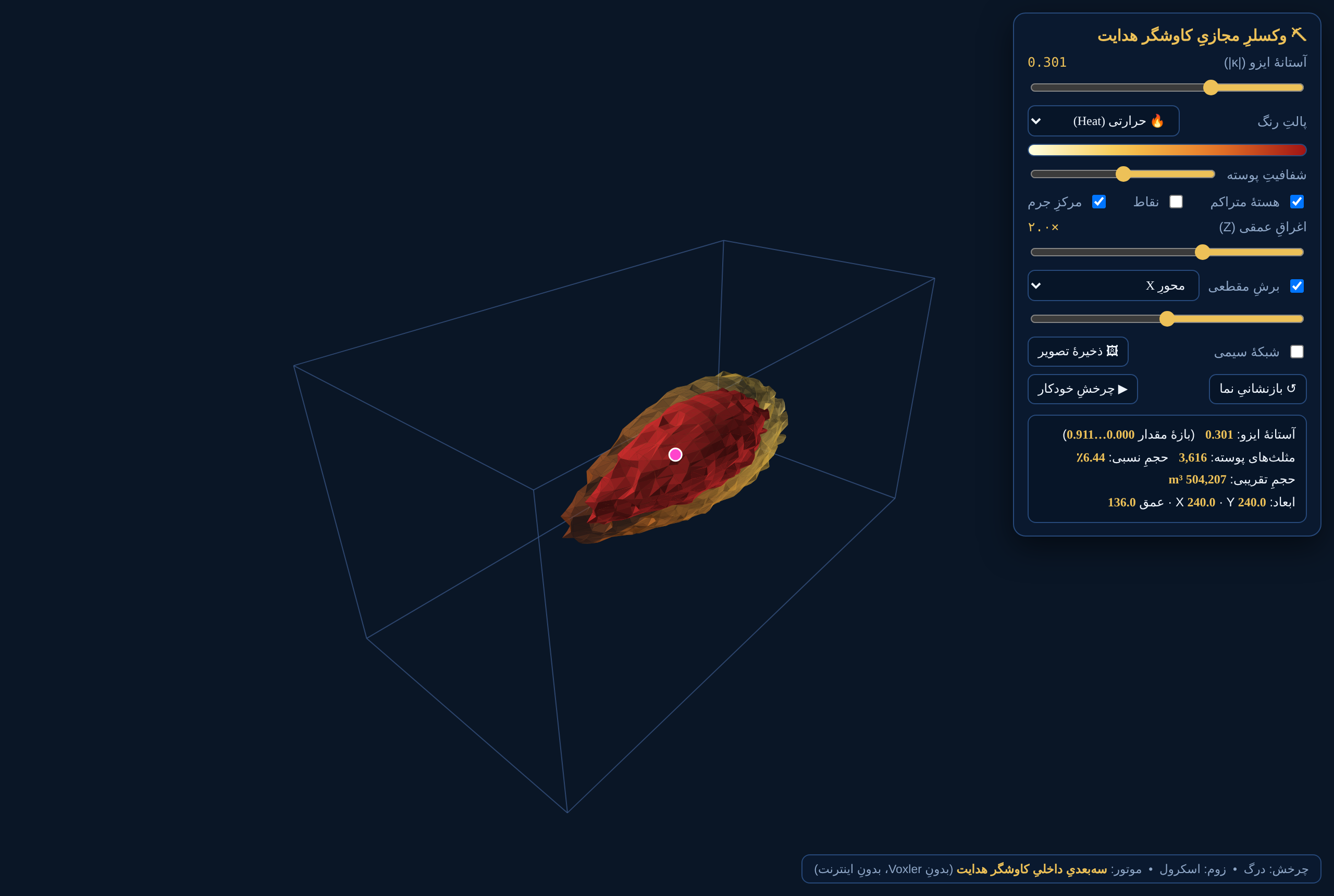
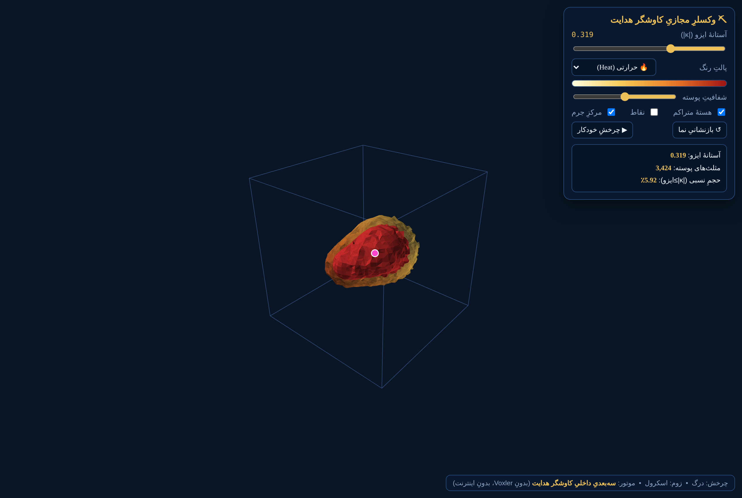
A self-contained isosurface engine (Marching Cubes) that renders inversion models directly inside Hedayat Explorer — no Voxler and no internet required. Adjustable isovalue, Heat/Swamp/Rainbow/Cold-Hot colormaps, shell opacity, dense core, scatter points, center of mass, vertical exaggeration, cut-away clipping, wireframe, PNG export and real-unit volume/extent readout.

Use case: Instant in-app 3D interpretation, offline.
Related: Advanced Geophysics — 3D Inversion Voxler 4 Automation Virtual Excavation Simulator
◳Real screenshot pending
Available
3D Visualization

Voxler 4 Automation

اتوماسیون Voxler 4

Optional COM automation that builds the Gridder → Isosurface network in Golden Software Voxler 4 (requires Voxler installed), with transparent shell, red dense-core isosurface, center-of-mass scatter and volume.

Use case: Advanced users with Voxler licenses.
Related: Virtual Voxler — Internal 3D Engine Advanced Geophysics — 3D Inversion
◳Real screenshot pending
Available
AI & Intelligence

Smart Analyzer (t3d / VTK)

تحلیل‌گر هوشمند (t3d / VTK)

Full automated report for imaging scanners (t3d / VTK): target detection, depth estimation from an excavation library, edge/saturation warnings, and logging of excavation results to improve future depth models.

Use case: Interpreting ground-imaging scanners.
Related: TeroVido / Scanner Import Change Detection / Repeat-Scan Comparison
AI Core (Local Knowledge Memory) ⤢ In Development
AI & Intelligence

AI Core (Local Knowledge Memory)

هستهٔ هوش مصنوعی (حافظهٔ دانش محلی)

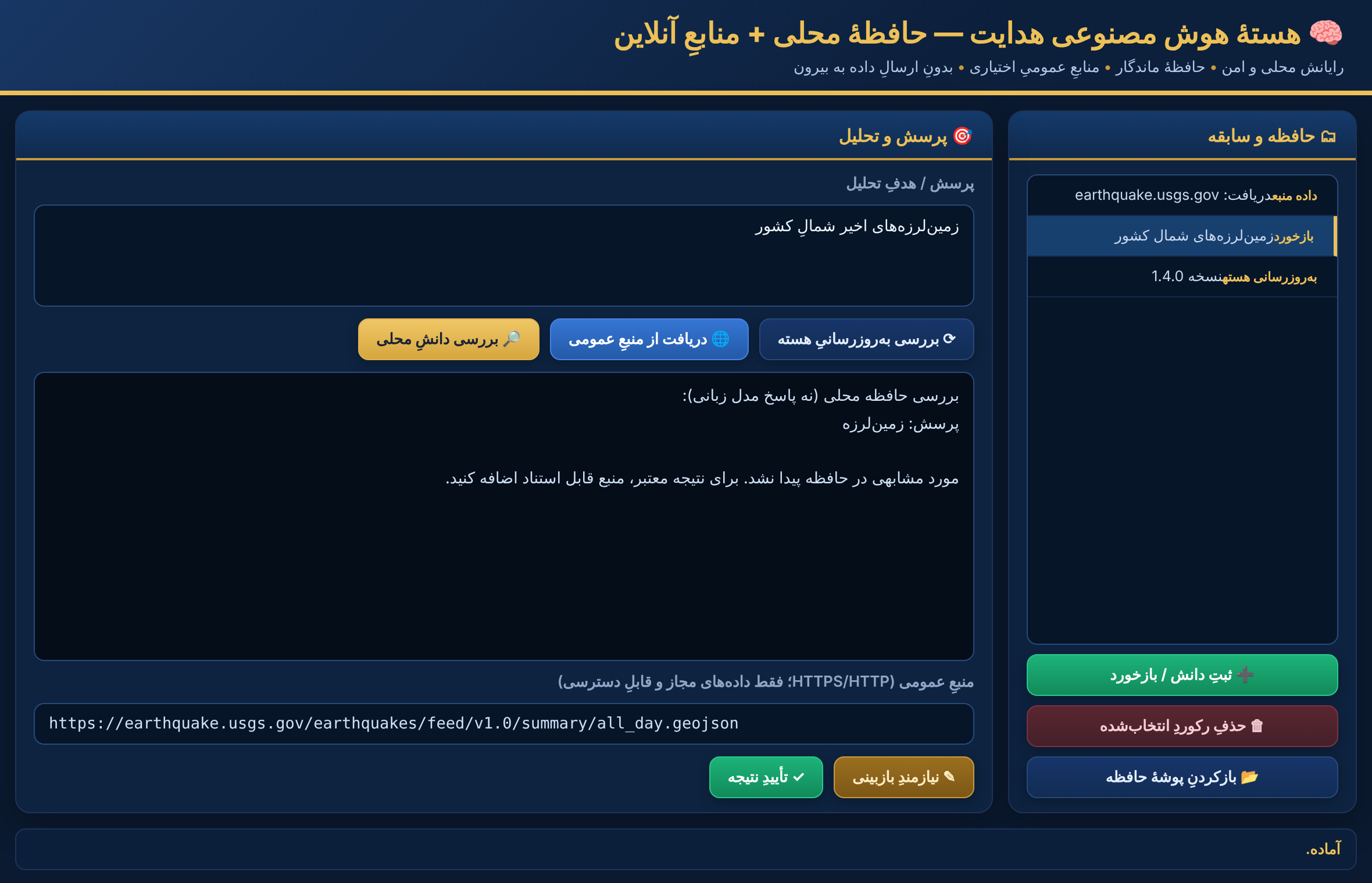
An isolated, privacy-first AI workspace: local knowledge memory, explicit expert feedback, optional retrieval from permitted public sources, and a secure core-update channel with SHA-256 verification. Data is never sent out without consent; results are not treated as truth without verification.

Use case: Knowledge capture and assisted interpretation.
Related: Smart Analyzer (t3d / VTK)
◳Real screenshot pending
Available
AI & Intelligence

Change Detection / Repeat-Scan Comparison

آشکارسازی تغییر / مقایسهٔ اسکن تکراری

Compares repeated scans of the same site; a target present across multiple repeat scans is scored as more reliable.

Use case: Confidence scoring and false-alarm reduction.
Related: Smart Analyzer (t3d / VTK) Cross-Section / Z-Profile
◳Real screenshot pending
Available
Geophysics & Inversion

Cross-Section / Z-Profile

مقطع‌زنی / پروفیل عمق

Plots signal variation between two points and estimates depth with an interactive model slider.

Use case: Quick depth and continuity checks.
Related: Professional Map & Spectral Filters Advanced Geophysics — 3D Inversion
◳Real screenshot pending
Available
Data I/O & Conversion

Hedayat Converter

تبدیل‌گر هدایت

Auto-detects the format of any input file and converts between CSV, Surfer GRD, ESRI ASC, VTK, Voxler DAT, XYZ and KML, with direct feed to the Hedayat engine and UAV-DEM micro-topography.

Use case: Universal format interoperability.
Related: Export Formats & Reporting DEM Intelligence
◳Real screenshot pending
Available
Data I/O & Conversion

Export Formats & Reporting

فرمت‌های خروجی و گزارش

Exports to CSV, XYZ, Surfer GRD, ESRI ASC, VTK, Voxler DAT, KML/KMZ, GPX, STL, OBJ, PNG images and PDF reports, plus body-volume and center-of-mass data files.

Use case: Deliverables for any downstream tool.
Related: Hedayat Converter Google Earth Integration
Secure File Transfer Center ⤢ Available
Connectivity & Transfer

Secure File Transfer Center

مرکز انتقال امن فایل

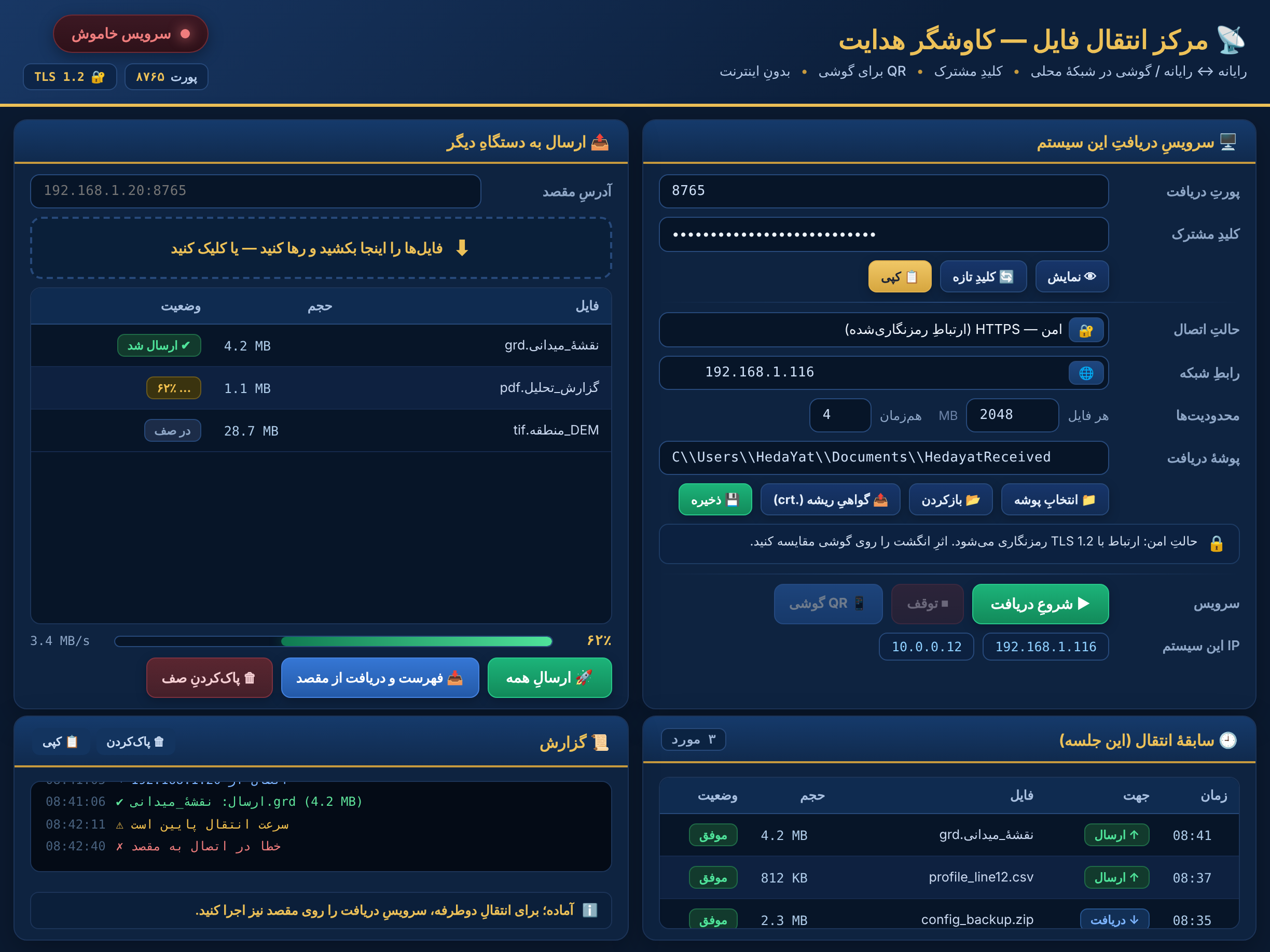
Computer-to-computer and computer-to-phone file transfer over the local network with TLS 1.2 encryption, a locally generated certificate authority with fingerprint pinning, shared-key authentication and QR pairing — no internet or cloud.

Use case: Moving survey data securely in the field.
Related: Connection Center
◳Real screenshot pending
Available
Connectivity & Transfer

Connection Center

مرکز اتصالات

Central management of device and network connections used across the acquisition and transfer modules.

Use case: Configuring hardware links.
Related: Secure File Transfer Center Device / Telemetry Reader
◳Real screenshot pending
Available
System & Platform

Global Multilingual Support

پشتیبانی چندزبانهٔ جهانی

Built-in interface translation across 35+ languages (Persian base, offline English, plus Arabic, Turkish, Russian, German, French, Spanish, Chinese, Japanese, Korean, Hindi and more) with full RTL and LTR layout.

Use case: Worldwide deployment.
Related: Main Console & 14-Step Engine
◳Real screenshot pending
Available
System & Platform

Field Log

یادداشت میدانی

On-device logging of field notes tied to scans and targets.

Use case: Recording operational context.
Related: Main Console & 14-Step Engine
◳Real screenshot pending
Available
System & Platform

License Manager

مدیریت لایسنس

Activation and license management for the software.

Use case: Product activation.
Related: Main Console & 14-Step Engine